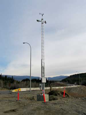
That thing at the Fish Lake cutoff...
If you go to this Alaska government site, and click the following: Map View... Haines/Skagway... Cameras... South East Alaska ... Camera.... you will see photos of the South Klondike Highway Summit taken within the hour. Also, at the same Site you can also access a nice little explanation as to road conditions on most of the roads in Alaska.
This is possible because of something called "Road Weather Information System". And you can see our own Yukon version beginning here at the Fish Lake Road: that is what that miniature tower with electronic doodads is all about. It comprises (1) pavement sensors in travel lanes; (2) atmospheric sensors next to the roadway; and (3) digital cameras to show weather and road surface conditions. Thus road surface temperature, de-icing chemistry, moisture, subsurface temperature, air temperature, relative humidity, wind speed and direction and precipitation are all measured, all the time. This information is constantly transmitted to a central server, work stations, maintenance offices, etc.

There are 2 other stations in the Yukon being established, also in the Whitehorse area, on high-volume parts of the highway (Meadows Golf Course and Lewes R south of Whitehorse).
In so doing, Yukon is joining a comprehensive network forming throughout the North American continent. Allan Baranyk, of our own Yukon Highways Dept tells me that Yukoners will eventually be able to get the same real-time level of road information as is now available on the 511 Alaska site.
The cameras, by the way, are not capable of capturing/recording vehicle speeds: Each active camera is polled 1- 4 times per hour, capturing a single still image each time. The ADOT&PF temporarily archive these images for a time period not to exceed 2 days.
posted by Mollie at 5:40 PM
![]()

0 Comments:
Post a Comment
<< Home